Seagrave's non-existent "Alternate Route"[A00]
A United Press (UP) news article with dateline 05 Jan 1945 reported:[A01]
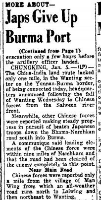
The last paragraph is key to the subject of an "alternate route" (emphasis added):
Chinese forces were reported only a mile from the village of Man Wing from which an all-weather road runs north to Loiwing and then northeast to Wanting.
Six days later, the CBI Roundup, 11 January 1945 provided an update:[A02]
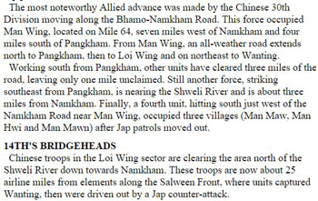
The first paragraph is key to this subject (emphasis added):
The most noteworthy Allied advance was made by the Chinese 30th Division moving along the Bhamo-Namkham Road. This force occupied Man Wing, located on Mile 64, seven miles west of Namkham and four miles south of Pangkham. From Man Wing, an all-weather road extends north to Pangkham, then to Loi Wing and on northeast to Wanting.
The road is not again mentioned in the news.
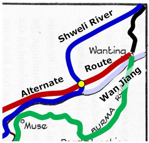
In 1946, Seagrave published his Burma Surgeon Returns and included this map which traced the road described above as the "Alternate Road" (colors added for clarity):[A03]
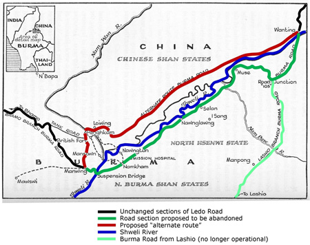
Seagrave mentioned the route in accompanying text (emphasis added):[A04]
five motorable roads that come together at Panghkam over which casualties could be jeeped to us. There's the motor road through Loiwing to Wanting, . . . .
Seagrave also gave detail which suggests that he might have been the source for that information. In the days immediately preceding the UP article, the approximate period Christmas 1944 to 06 Jan 1945, he had found himself stalled at the Chinese 30th Division headquarters on the Bhamo-Namhkam Road near Kaitik (Mile 32). During this period, he noted:[A05]
. . . officers of the Air Force, Tanks, Corps Artillery, First Army, kept dropping in continually with their maps to ask about the geography of the Namkham Valley, locations of fords and marshes, gravel banks and sand, and level plateau areas.
But how he would have obtained information about the alternate road is unclear:
In Burma Surgeon, he had recorded having traveled from his hospital location at Namhkam up the Burma Road to Longling, China in 1937[A06] and later to Kunming.[A07] To access the Burma Road, he would have gone east along the south side of the Shweli River to the intersection with the Burma Road at "Road 105".
In addition, in late 1939 or early 1940, he provided medical support to the CAMCO facility at Loiwing which took him southwest and then north to Loiwing three times a week.[A08] However, there is no record of his having continued northeast along the "Alternate Route" to intercept the Burma Road.
In any case, the implication was that the described route (in red on the map above) was to be preferred over the previously accepted routing (in green) of the Ledo Road.
That implication, however, was wrong. The problem lay in the alternate route between Mu-Se and Wanting (the upper right corner of the map). What Seagrave's map shows is:[A09]
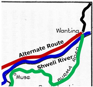
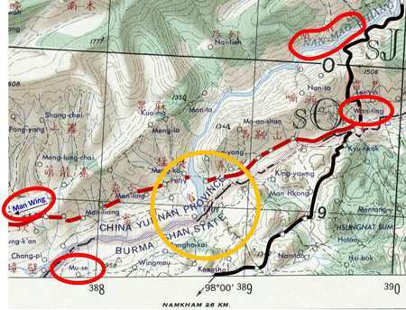
However, the Shweli (in blue) does not flow as shown, but rather comes down from the northeast to turn southeast and then west where a small tributary, the Wan Jiang, joins it from Wanting to the northeast:[A10]
At the time that the subject of the Alternate Route materialized, the suspension bridge at the western end of the Shweli River plain lay destroyed by Allied bombing. To cross the Shweli implied fording it near that point; someone unfamiliar with the terrain might have assumed this to be unfeasible. The alternate road would have avoided fording the Shweli. And if it had existed as visualized, it would have avoided the fictitious Shweli crossing at Wanting.
Here is a post-war US Army map of the area showing the Shweli (here the Nam Mao) cutting through the "Alternate Route" (dark red) between Mu-Se and Wanting. A "Ferry" is called out on the map as the method of crossing the gap:[A11]
As noted, the waterway at Wanting is not the Shweli, but rather a very minor tributary of the Shweli (so minor that it is not shown on the map above). The Shweli (aka Nam Mao above) comes down from the north between Man Wing and Wanting. Following the north bank of the Shweli towards Wanting would have still required crossing the Shweli, about 10 km (6 mi) west of Wanting. During the dry season in early 1945, the Shweli, there on a flood plain, could, no doubt, have been forded; but with the arrival of the wet season and the annual flooding of the Shweli, that option would have ended, and a bridge would have been required.
Allied planners had long before realized that the site of the destroyed suspension bridge at the west end of the Shweli River plain was a better option that trying to span the Shweli closer to Wanting: the replacement bridge had been designed for it with components ordered and shipped in time for construction to start in mid-January 1945.[A12] In addition, the roadway on the north bank of the Shweli was in Chinese territory and, at that time, was assumed never to have been improved, whereas that on the south bank had been improved by the British before the war.
Another significant factor in choosing the road on the south of the Shweli would have been assuring access to Gordon Seagrave's hospital at Namhkam: even as destitute as it appeared when the area again came under Allied control in early 1945, Seagrave and staff offered the only medical services of their class in the area.
That the concept of an "alternate route" was never again discussed in the news suggests that reporters / editors became aware of the all of the above.
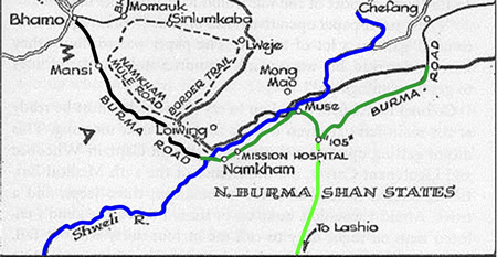
Why the alternate route was shown on Seagrave's map is unclear. There is a more general map of the area (BSR, p 203) which correctly traces the course of the Shweli coming in from the north, but it wrongly locates the Burma Road's border crossing point much too far east:
A conclusion to be drawn is that the maps in Seagrave's Burma Surgeon Returns are intended for general information only.
The ultimate conclusion is that the "Alternate Route" was never really an option. It would be interesting to learn of the origin of the concept.
|
The erroneous linking of Loiwing Airdrome to the USAAF Air Transport Command's Loping Airfield on the Hump Route[LA00]
With the coordinates of Suili given in an Allied intel report, I scrutinized the area on Google Earth for any evidence on the ground. At some point during that search, I found a tiny icon which opened into something like this:[LA01]
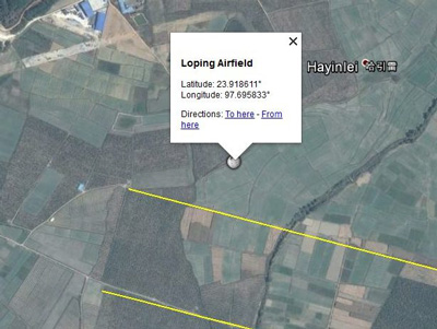
The information "balloon" at that time differed from the above in that it referenced an article titled "Loping Airfield" in Wikipedia. I followed the prompt to the webpage, and was encouraged by its presentation. The sidebar gave the coordinates for the location:[LA01a]
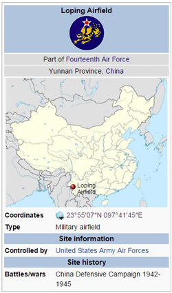
And those coordinates were the same as those in the info balloon in Google Earth, just in a different format. The text further reinforced the connection:[LA01b]
"4 miles west-northwest of Jiexiangxiang" proved to be correct for the Suili site after I finally located Jiexiangxiang (and that process I've since lost).
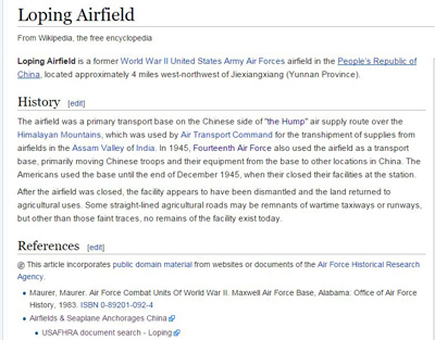
Wikipedia's first paragraph under "History" appeared plausible; and the second paragraph was very encouraging with:
. . . some straight-lined agricultural roads may be remnants of wartime taxiways or runways, but other than those faint traces, no remains of the facility exist today.
And with that hint, I proceeded to compare the poor quality Allied intel report illustration with the current Google Earth image and eventually found those road remnants. The result was my aligning the Allied aerial photo with similar features on the ground and my defining the location of Suili. Precisely. This was the result of the encouragement in the Wikipedia article on Loping Airfield.
However, a reviewer reasonably questioned the logic of the Air Transport Command having located a base so close to the one at Bhamo.[LA01c] And, as it turned out, Loping was not located at the airfield at old Loiwing Airdrome.
With the name, Loping, established, I ran a Google search on "Loping", but found more references to antelope than airfields. Eventually, while searching for something else, I came across a map showing the radio beacon bearings used in flying the Hump. It appears in a CBI Theater webpage by Wendall A. Phillips, a retired ATC Radio Operator:[LA02]
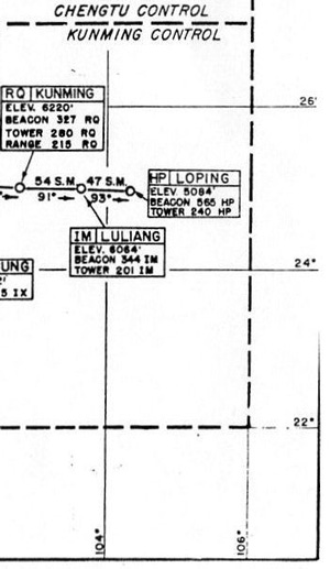
With that, the Air Transport Command's Loping was seen to have been located about 100 miles directly east of Kunming; on Google Earth in that area, a local name, Luoping, was prominent. So the Allies had shortened Luoping to Loping. Googling "Luoping" produced a long list --- the name is obviously common; but geographical references were dwindling by page four and none was the "right" Luoping. I then qualified the search for "Luoping" by adding "Yunnan", and the "correct" Luoping was finally included in the Google list.
A plot of the various radio beacon bearings that led to Luoping Airfield in Phillips's document roughly defined a triangular area centered on N24°35 E104°22; however, no evidence of an airfield is visible within that area. The bearing plots would have involved some error since the locations of the airfields associated with the beacons were used as origins, whereas the beacons themselves may have been located some distance from airports in order to use greater elevations available in surrounding mountain ranges. Familiar with the area, Lieuwe Montsma pointed out a feature centered at N24°50.80 E104°18.56, about 11km SSW of the plotted area which could only have been the Loping runway; while modern facilities not related to the runway are present, remains of old revetments are still visible:[LA03]
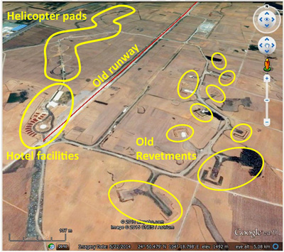
He also provided a link to ground views ("street views") of current day hotel facilities for tourists whose room rates include helicopter rides to view the local canola fields in blossom --- for which the area is now famous. See Luoping Canola.
Afterword: while this exercise demonstrates that the USAAF WWII Air Transport Command's Loping Airfield was not located at Suili, numerous tour services include visits to the Suili site, but identify it as the Loping Airfield, apparently per the mistake in Wikipedia. Suili is a valid historical site; but as the location of Loiwing Aerodrome out of which the Flying Tigers briefly flew early in 1942.
Air Force Historical Research Agency (AFHRA) index lists the earliest records for Loping Airfield as 01 September 1944. However, all unit records found on the Internet cover the period 17 May 1945 through Nov 1945:[LA04]
The 1359th Army Air Forces Base Unit was present from 17 May through 05 Sep 1945.
The 319th TCS (Troop Carrier Squadron) was present Sep-Oct 1945.
The 25th Fighter Squadron (PACAF) was located there Sep-Nov 1945.
The 788th AAFBU (158th AACS Sq) had a communications detachment at Loiwing till 24 Oct 1945.
The 130 Squadron of the Army Airways Communications System was present from 01 Nov to 06 Dec 1945.
Phillips's Assam-Bengal-China Air Routes manual from which location data for Loping was obtained was dated 10 Jul 1945.
|
Map Errors
Man Wing Airstrip
On 06 Oct 2007, ick53993 wrote to the Yuku Loiwing thread in part:[E01]
I understand "unidentified airfield near the Burma border" is the one near another "Man Wing" at Mu-se. The US Army map shows the landing area there. . . . This is in Burma, on the left bank of Shweli River [ie, left bank, looking downstream]. . . .
The question illustrates two problem areas in map work:
1. 'Unidentified airfield'. The unidentified airfield is shown on a US Army map dated 1958.[E02] From glancing through several maps in that 1958 series, it would appear that the standard at that time was not to associate names with airport symbols.
But there is another problem in this example: the symbol is incorrectly located. Oddly it is halfway between the two airport sites known to have existed at Muse: the more southerly airstrip, in the Shweli River flats, would have been obliterated in the 1945 rainy season, and the mapmaker presumably had that information in 1958 and should not have called out the site. The more northerly airstrip is still visible today. iPad Galileo Offline Maps show a airport symbol correctly locating it. OpenStreetMap also correctly locates the northerly strip and labels it "Old Airport".[E03]
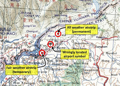
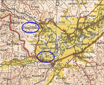
2. Different locations with the same name: 'Another "Man Wing"': Not only are there two "Man Wings" as noted by ick53993, they are within 38km (24mi) of each other along the Ledo Road, and each is within 6.5km (4mi) of a different "Panghkam". Near Muse, this:[E04]
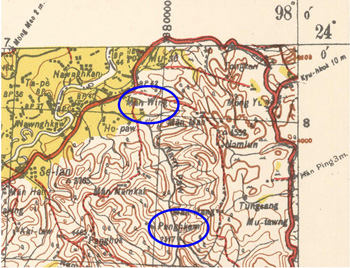
and near the Loiwing Factory strip this:[E05]
This is an example of a source of confusion that is typical both in Burma and Thailand. Thai topo maps all contain the warning:
There are numerous identically named
villages
portrayed on this map.
Survey of India maps were not so courteous.
Shweli bridge status
As already noted, the original suspension bridge across the Shweli had been destroyed by Allied bombing on 21 Apr 1944, and then replaced by the Allies around 15 Mar 1945 with a second suspension bridge which still exists today.
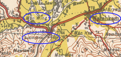
The Survey of India map of the area, with "Major communications verified during . . . 1940", correctly calls out the bridge:[E06]
However, with the bridge above destroyed in 1944 and replaced in 1945, the 1958 US Army map nonetheless calls it out as "Bridge destroyed", with the actual location of the bridge obscured:[E07]
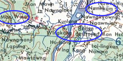
While the 1967 US Army map also calls it out as "Bridge destroyed":[E08]
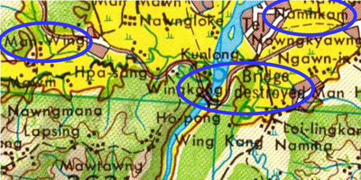
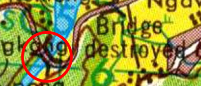
the bridge symbol, inconsistent with the label, spans the river:[E09]
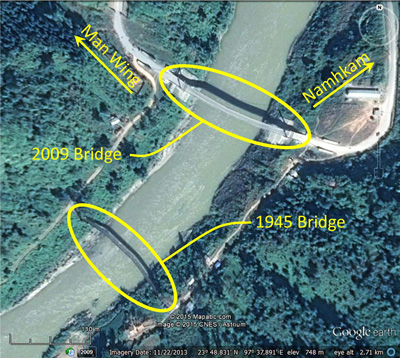
And, for record purposes, Google Earth's view of the immediate area (in much larger scale than the maps) clearly shows, now, two suspension bridges in the immediate area, one of them the bridge erected in 1945:[E10]
The immediate conclusion to be drawn from this is that the US Army maps of 1958 and 1967 are in error. The larger conclusion to be drawn --- lesson learned, so to speak --- is that no source is infallible.
|
|
Emphasis may be added, as relevant, to various excerpts quoted here.
Events appear muddled here chronologically.
A00.^ The topic was generated by observations of Lieuwe Montsma (att to email of 1406 hrs 31 Dec 2014).
A01.^ San Mateo Times, 05 Jan 1945, p 2 via NewspaperARCHIVE. Image extracted and enhanced with IrfanView by author.
A02.^ CBI Roundup webpage is unpaginated. Paragraph appears under lead article titled "Sultan's Chinese Seize Man Wing".
A03.^ BSR, p 244.
Annotations follow comments by Lieuwe Montsma. Image was enhanced with IrfanView and annotated using Microsoft Publisher by author.
Montsma notes that a more general map of the area, BSR p 203, shows the Burma Road and the Shweli River as separated.
A04.^ BSR, p 235.
A05.^ BSR: general info from pp 227-230; quote is from p 230.
A06.^ BSR, pp 79-82.
A07.^ BSR, pp 98-103.
A08.^ BSR, pp 113-114.
A09.^ Extract from Seagrave, ibid, image enhanced with IrfanView and annotated with Microsoft Publisher, by author.
A10.^ Extract from Seagrave, ibid, image enhanced with IrfanView, and modified and annotated using Microsoft Publisher, by author. Changes follow those pointed out by Lieuwe Montsma (email 1339 06 Jan 2015).
A11.^ US Army Map Service Edition 1‑AMS, Series U542: Lung‑Ling, China; Burma map NG 47‑14 (Feb 1956).
Image enhanced by IrfanView and annotated using Microsoft Publisher by author.
A12.^ CBI Order of Battle: 209th Engineer Combat Battalion.
LA00.^ This account is NOT intended to belittle Wikipedia. I rely on Wikipedia; I use it every day, with confidence, but also with caution --- as I do anything, whether on the Internet or hardcopy.
The beauty of Wikipedia is the ability to update and correct its information. Material in hardcopy form, such as old encyclopedias, had to be amended in annual yearbooks, which had to be purchased, if funds were available, by individuals or libraries.
I corrected the Wikipedia article, Loping Airfield, on 21 Jan 2015. The reasons for the corrections are summarized in its Talk section.
LA01.^ The small icon I had found no longer appears on Google Earth's imagery. What is shown here, I have generated by going backwards and clicking on the location coordinates in the Wikipedia Loping Airfield article; but, at first, I didn't know about the Loping connection, so the appearance of the icon was apparently a transitory function of Google Earth and/or Wikipedia, and my happening on it was purely chance. Image captured with Gadwin PrintScreen. Yellow lines define northerly and southerly bounds of east-west runway.
LA01a.^ Copied 19 Jan 2015 for record purposes since I subsequently changed it.
LA01b.^ Ibid.
LA01c.^ Lieuwe Montsma email of 1515 hrs 27 Dec 2014.
LA02.^ Extract from image at Route Easy. Part of Assam-Bengal-China Air Routes. Extracted and enhanced with IrfanView by author.
LA03.^ Google Earth oblique view looking north at N24°50.0 E104°18.5; image captured with Gadwin PrintScreen, enhanced with IrfanView, and annotated with Microsoft Publisher by author.
LA04.^ Sources for the various units are as shown:
1359th: CBI Order of Battle for Air Transport Units.
319th: C-47/R4D Skytrain Units of the Pacific and CBI by David Isby (Osprey, 2007), no page no.
25th: 25 Fighter Squadron (PACAF).
788th: CBI Order of Battle: Army Airways Communications System Units.
130th: Air Force History Index.
E01.^ ick53993 post on 0534hr 08 Oct 2007 on Yuku Warbirds' Loiwing thread --- since removed.
E02.^ Pointed out by Lieuwe Montsma in emails of 1724 17 Jan 2015 and 1318 19 Jan 2105.
E03.^ The image is a composite of parts of US Army Map Service products, Edition 1-AMS, Series U542: the Lung-Ling, China; Burma map NG 47-14 (Feb 1956) and the Hsenwi, Burma, China map NF 47-2 (Apr 1958). The airfield symbol was pointed by Lieuwe Montsma, as were the identifications in Galileo and OpenStreetMap. Images were enhanced with IrfanView, and joined and annotated with Microsoft Publisher by author.
E04.^ Part of Hsenwi (93 E) No. F-47 B, ibid. Extracted and enhanced with IrfanView and annotated using Microsoft Publisher by author.
E05.^ Ibid.
E06.^ Excerpt from Hsenwi (93 E) No. F-47 B, Provisional GSGS [Geographic Service of the General Staff] 4218 (Survey of India), as the 3rd Ed 1944-AMS 2 (topo data 1926). Image extracted and enhanced with IrfanView and annotated using Microsoft Publisher, by author.
E07.^ Excerpt from US Army Map Series U542, Edition 1-AMS, Hsenwi, Burma, China map NF 47-2 (Apr 1958). Image extracted and enhanced using IrfanView, and annotated using Microsoft Publisher, by author.
E08.^ Excerpt from US Army Map Series 1501 Air, Sheet NF 47-2, Edition 3, Hsenwi, Burma, China. Image captured from pdf image with Gadwin Printscreen, enhanced using IrfanView, and annotated using Microsoft Publisher, by author.
E09.^ Excerpt from Hsenwi, Burma, China, ibid.
E10.^ Google Earth imagery dated 21 Feb 2015. Image captured using Gadwin Printscreen, enhanced using IrfanView, and annotated using Microsoft Publisher, by author.
|